
The Ultimate Guide to Jewel Basin, Montana
There are so many amazing places for wilderness in Montana that most people don’t know about when they visit, and a big one I personally love is Jewel Basin. This hiking area is huge and set aside for recreation, meaning you aren’t going to see the same number of people as you would in the national parks. The best part? There are sights and trails that are equally as beautiful, in my opinion. Make sure to add it to your Montana road trip when you go!
Everything you need to know about Jewel Basin
Here’s what you need to know about hiking and adventuring in Jewel Basin!
[lwptoc hideItems=”1″]

Map of Jewel Basin
Where is Jewel Basin?
Jewel Basin is a hiking area in the Flathead National Forest, Montana. It is located in the northwest corner of the state on the southern side of Glacier National Park. Jewel Basin is spread over 15,349 acres and it is an area specifically formed for recreational activities such as hiking and camping.
Jewel Basin sits at the northern end of the Swan Mountain Range and much of its landscape is characterized as alpine. There are 27 lakes and 35 miles of hiking trails in Jewel basin Montana. It is an area of staggering natural beauty with limited development and no access for motorized vehicles.
When is the best time to visit Jewel Basin?
The high season in Jewel Basin runs from July to August. These are the sunniest months of the year with the most agreeable weather for hikers. The trails become particularly busy on weekends and during public holidays. Fringe months of May-June and September may offer cooler weather with quieter trails.
Snow and ice often cover the peaks well into July. During the winter months, weather conditions are extreme and severe, and it’s not advised to visit the Jewel Basin hiking area. Blizzards, sub-zero temperatures, and high winds all strike the Swan Mountain Range and only experienced hikers should attempt to access Jewel Basin in winter.
Where do I gain access to Jewel Basin?
Jewel Basin MT is framed by highways 2, 83, and 35. Echo Lake Road and Jewel Basin Road lead into the heart of the nature area. The easiest way to access the hiking zone is by car or van. Driving into Jewel Basin allows you the freedom to access all the Kalispell hiking trails.
There are a scattering of small towns nearby with Kalispell being the best place to stock up on supplies before your trip. Many hikers choose to drive up the switchbacks from Echo Lake to the Camp Misery trailhead. Alternatively, there are numerous remote logging roads from Hungry Horse Reservoir that permit access to the western trailheads.
Do I need a backcountry permit for Jewel basin?
A Jewel Basin hike is the ultimate form of backcountry freedom. No permits are required to access this hiking area and backpackers have the option to explore anywhere they like – on or off the trail. However, there are general pieces of advice for backcountry hikers visiting the area.
It’s recommended to hike in pairs when visiting Jewel Basin. Before leaving for your trip, you should provide a brief itinerary of your journey to a trusted friend or family member. That way, if anything does go wrong, there are people who know where to send help if you’ve had an accident.
Do I need a camping permit for Jewel Basin?
Wild camping is permitted in Jewel Basin and no permit is required. There are a scattering of designated campsites on the fringes of Jewel Basin, but for the most part, camping pitches must be sought independently in the backcountry.
Campers are asked to be mindful of their environment and to leave no trace. A minimal impact attitude helps to preserve the natural beauty of the Jewel Basin area for other hikers. Try to pitch your camp away from the main trails and leave your site as you found it. Collect all trash and bury any human waste away from lakes and rivers.
Are campfires allowed in Jewel Basin?
Campfires are allowed in Jewel Basin but within limits. Open campfires should be limited where possible, and it’s advised that hikers avoid cutting down timber. There are also no campfire perimeter zones around many of the lakes including Birch, Crater, Twin, and Picnic Lakes.
This is due to the overuse of campfires causing high amounts of ash to run into the water systems. The pH change may disrupt the lake ecosystem and the felling of trees weakens the soil causing flooding and runoff. Responsible, controlled campfires or the use of lightweight camp stoves are highly recommended.
Can I fish in Jewel Basin?
The lakes of Jewel Basin are a spectacular habitat for many aquatic species. Fishing is a popular pastime in Jewel Basin with many desirable species to be caught. Every three years, the lakes are stocked with Westslope Cutthroat Trout. There are also hybrid populations of rainbow and Yellowstone cutthroat trout that inhabit many of the lakes.
Fly fishing and coarse fishing using spinners are the most popular angling techniques in the Jewel Basin lakes. Most fish caught are around 10-12 inches in size with some specimens reaching 16 inches or more. Anglers are advised to venture to the more remote lakes to avoid over-fishing popular waterways.
 Are dogs allowed in Jewel Basin?
 Are dogs allowed in Jewel Basin?
Dogs are allowed in Jewel Basin but with restrictions. Dogs must always be kept on a leash – both on and off any hiking trails. Dogs must be kept under physical restrictive control for the duration of their stay in the Jewel Basin.
Although this may seem overly strict, it is mainly to protect local wildlife. Dogs can scare nesting birds, startle grazing mammals, and disrupt the delicate ecosystem present in Jewel Basin.
Are there bears in Jewel Basin?
Both black bears and grizzly bears are present in Jewel Basin. As such, certain precautions should be made when hiking in bear country. Food should never be left out in open containers. Bear canisters and bags should be used to deter bears from approaching your camp.
Pack bear spray and bear bells to ensure you never get too close to these powerful predators. Keep an eye out for bear scat and new carcasses on the trail. Watch out for fresh paw prints and don’t be afraid to chat while you’re hiking as this avoids the chance of you startling an unassuming bear.

The best Jewel Basin hikes
For hikers wishing to find a truly wild and off-grid experience, Jewel Basin Montana offers exactly that. Many of the hikes can be done in a day with the option to string together some multi-day hikes with backcountry camping. Routes come in a range of difficulties each offering a different sample of this sprawling nature area.
Alpine Big Hawk Trail #722
Difficulty: Moderate to challenging
Distance: 17.2 miles
This is a difficult mountain trail to the west of Jewel Basin. The trail begins near Broken Leg Mountain and follows a ridge north. It cuts between Crater Mountain and Three Eagles Mountain before winding beneath Mount Aeneas. There are many ups and downs on this trail and the ascent is grueling.
It’s advised to bring a map and GPS on this route as it’s easy to lose the trail in the backcountry. The path is littered with rocks and rutted with roots but that all adds to the allure of the trail.
Mount Aeneas Trail #717
Difficulty: Challenging
Distance: 6.2 miles
Mount Aeneas is a 2,279-meter-high peak in the Jewel Basin hiking area. The trail is easily accessed from the Camp Misery Trailhead which can be driven to directly from Echo Lake. However, this is probably the only aspect of the hike that is easy.
The path is steep and highly demanding. For most of the year, the trail is inaccessible due to snow. There is a long and constant incline from the trailhead straight to the summit. However, the views from the peak are sensational with broad panoramas across the mountains of Montana and the Flathead Reserve.
Did you know that I am leading some local tours up Mount Aeneas this summer? You can check them out here:
Clayton Creek Trail #420
Difficulty: Moderate
Distance: 5.3 miles
In the heart of the Jewel Basin hiking area, there’s the beautiful and remote Clayton Lake. Situated in a valley trough beneath Tongue Mountain, this is a wonderful sample of the best Jewel Basin hikes.
The hike is of intermediate difficulty and follows a steady incline up towards the lake. Clayton Lake is an excellent place for fishing or to pitch a tent after a long day’s hike. The trail is overgrown and rough in parts, but this only makes the adventure more exciting! Take your time to enjoy the berry bushes and wildflowers that line the trails.
Birch Lake Trail
Difficulty: Moderate
Distance: 6.2 miles
The Birch Lake Trail climbs sharply up the mountainside before evening out to follow an alpine path along the top of the valley. It is another one of the Kalispell hiking trails that is fairly easy to access due to the parking spot at the Camp Misery Trailhead.
From the trail, there are expansive views across the Flathead Valley. At first, the path cuts through woodland before reaching the mountain edge where hikers can gain commanding views of the Bob Marshall, Swan, Mission, and the Salish Mountains. The hike culminates in the wonderful Birch Lake which is another excellent fishing location.
Picnic Lakes Trail
Difficulty: Challenging
Distance: 6.2 miles
The Picnic Lakes trail is a path that loops through the lakes, over Mount Aeneas, and along the #717 and #392 hiking trails. The route is generally walked counterclockwise from the Camp Misery Trailhead.
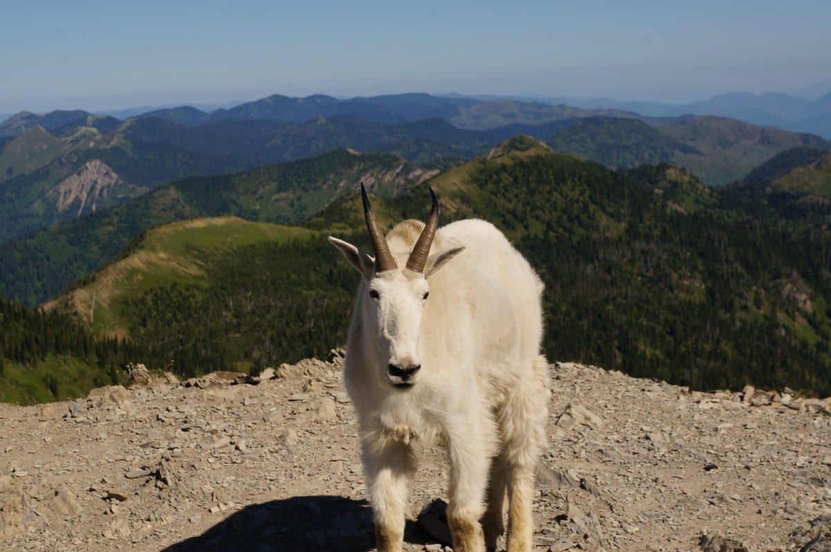
Initially, the path is steep with some hairpin bends rapidly gaining altitude. The trail then ascends a ridge up to Mount Aeneas. From here, the trail drops down to the Picnic Lakes where you can fish, swim, and relax, before heading back to the car park. There is plenty of wildlife to see along the trail particularly the mountain goats that live in this area.
Graves Creek Trail #1
Difficulty: Challenging
Distance: 17.8 miles
This long-distance hike cuts directly through Jewel Basin from west to east. The route begins at the Camp Misery Trailhead and joins the ridge where many trails converge. The path threads its way past the Picnic Lakes, Black Lake, and many other water features before dropping down towards Hungry Horse Reservoir.
The trail is very rugged and unkempt. There are sections of the path that are not well-maintained and log falls are common. A good GPS navigator or map and compass are required to accurately stick to the trail. Fantastic views, but a challenging trail to follow.
Pioneer Ridge Trail #71
Difficulty: Moderate
Distance: 7.5 miles
This trail begins near the Hungry Horse Reservoir just off the National Forest Development Road 895. The path cuts up through thick undergrowth and many switchbacks before joining a highline trail through the Jewel Basin hiking area.
On top of the ridge, the trail is exposed to wind, sun, and rain. However, this means the views are extraordinary with fantastic scenery all around. There are many good opportunities for wild camping, but hikers should be comfortable bushwhacking through the backcountry as this is a seldom-walked trail.
Wheeler Creek Trail #64
Difficulty: Easy to moderate
Distance: 2.8 miles
This trail begins from the Wheeler Creek Trailhead which is a great access point for the southern sections of the Jewel Basin. It is less of a designated trail and more of an open area for exploration. There are very few specific route guidance options, and this is a hike that should only be attempted by those confident with navigating through the backcountry.
Tongue Mountain Trail #55
Difficulty: Challenging
Distance: 23.5 miles
This is a long, multi-day hiking trail that stretches right across the Jewel Basin hiking area. The trail begins at the Camp Misery Trailhead, but unlike many of the other paths, it cuts north towards Tongue Mountain before heading east through the basin.
The route passes Clayton Lake and descends to the Hungry Horse Reservoir before returning along the same trail. The path is narrow but in relatively good condition. Some areas are overgrown but mostly the trail follows alpine ridges that provide an in-depth experience into the Jewel Basin hiking area.
Blackfoot Lake Trail #719
Difficulty: Easy to moderate
Distance: 3.3 miles
This is another relatively unknown hiking trail in the Jewel Basin. Some of these secret routes really pay testament to how wild a nature area this is. With many paths that simply have a trailhead and seem to disappear into the deep forests and frosty mountains, it’s hard not to appreciate the isolation in such a place.
The trail begins at Jct. Tongue Mountain Trail #55 and ends at Jct. Graves Creek Trail. In between, backcountry navigation will be required as the trail is overgrown and not properly maintained. Definitely a route for the adventurous!
Have you ever been to Jewel Basin? Let me know your favorite hikes in the comments!
Like this post? Save it for later!


Want more information on Jewel Basin? Check out these articles:


